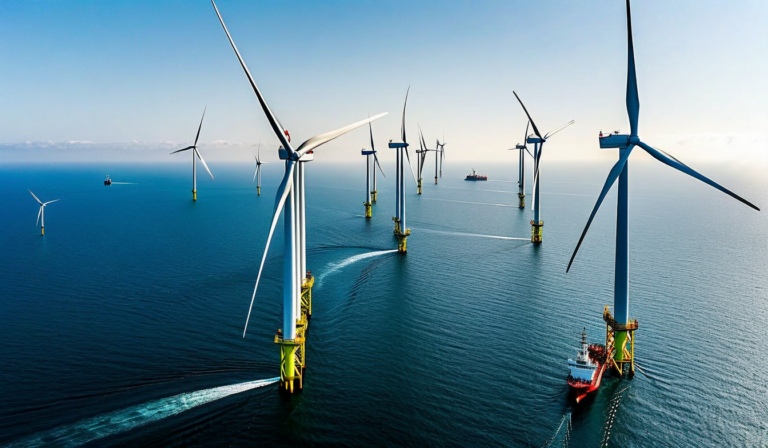
The North Sea is simultaneously one of the world's busiest shipping corridors and one of the world's most ambitious offshore wind development zones. More than 50,000 vessel movements pass through the Dover Strait annually — the busiest maritime chokepoint on Earth — and they do so increasingly in proximity to offshore wind installations whose combined capacity is growing by gigawatts per year. Hornsea One and Two, Dogger Bank, Hollandse Kust: these massive wind farms occupy tens of square kilometers of the same sea areas that tankers, bulk carriers, and container ships have transited for decades.
The intersection of maritime traffic and offshore energy infrastructure creates a specific and growing safety challenge. A vessel drifting onto a wind turbine foundation poses catastrophic risk: the structural damage to both vessel and installation, the pollution and fire risk from a loaded tanker, and the electrical hazards from severed inter-array cables can produce consequences that dwarf most conventional maritime casualties. Managing this risk requires AIS-based monitoring systems capable of detecting vessels approaching safety zones, predicting trajectories in near-real-time, and alerting both the vessel and the installation operator before an intrusion becomes an emergency.
The Regulatory Framework: Safety Zones and Navigation Restrictions
Under SOLAS Chapter V Regulation 22a, coastal states may establish mandatory ship reporting systems and vessel traffic services in areas with special navigational hazards. Offshore wind installations are designated as obstructions under SOLAS and require charting, lighting, and marking per IALA recommendations. Most coastal states with significant offshore wind development have established mandatory safety zones of 500 meters radius around each turbine foundation, enforceable under national maritime law. These zones are charted on official nautical charts and published in Notices to Mariners.
However, the 500-meter mandatory safety zone is a minimum designation primarily aimed at preventing vessel-foundation collision. The operational safety consideration is more nuanced: a vessel doesn't need to actually enter the 500-meter zone to create a safety concern. A vessel on a drifting trajectory, a vessel that has lost propulsion while within the wind farm exclusion zone but outside the individual foundation safety zones, or a vessel that has inadvertently entered the wind farm during reduced visibility conditions — all represent risk situations that the 500-meter rule alone doesn't address.
Port State Control inspectors and maritime accident investigators increasingly assess whether vessel masters maintained adequate situational awareness of nearby wind installations, whether appropriate chart corrections incorporating wind farm boundaries were applied, and whether bridge watchkeeping procedures included explicit checks for wind farm proximity on relevant passages. SOLAS Chapter V Rule 34 requires that passage plans include all areas of navigational hazard, and wind farm zones now routinely appear in that category — masters who plan passages that transit wind farm boundaries without documented justification face significant PSC risk.
AIS-Based Wind Farm Traffic Monitoring Systems
The most effective wind farm traffic monitoring systems combine AIS vessel tracking with trajectory prediction algorithms to provide early warning of potential intrusions. The core capability is straightforward: a terrestrial AIS receiver network covering the wind farm area (typically 2 – 4 receivers positioned to ensure overlapping coverage with no line-of-sight gaps) continuously tracks all vessels within range. The monitoring system applies a safety buffer — typically 2 – 3 nautical miles beyond the wind farm boundary — and generates alerts when vessels enter this buffer on a heading that intersects the wind farm zone.
The trajectory prediction component distinguishes useful safety systems from simple proximity alarms. A vessel 3 miles from the wind farm boundary heading directly toward it at 12 knots will reach the boundary in 15 minutes — enough time for a radio call to the vessel and a course correction. The same vessel at 3 miles on a parallel course is no concern. Trajectory prediction uses AIS COG (Course Over Ground), SOG (Speed Over Ground), and the vessel's MMSI to generate a predicted position track over the next 30 – 60 minutes, evaluating whether the track intersects the protected zone under current movement parameters.
For vessels that exhibit erratic movement patterns — stopping, drifting, making multiple course changes — the system must apply additional logic. A vessel that has been stationary for 20 minutes within 1 mile of the wind farm boundary, with an engine not known to be under repair, may be experiencing mechanical difficulty. AIS Class A transponders broadcast navigational status codes including "not under command" and "restricted in ability to manoeuvre" — when these are detected in proximity to wind infrastructure, they should trigger elevated alert levels and potentially emergency response protocols.
Coordinating CTV and SOV Operations Within the Farm
Wind farms have their own vessel fleets: Crew Transfer Vessels (CTVs) that ferry technicians to turbines for maintenance, and Service Operation Vessels (SOVs) that serve as mobile bases for extended maintenance campaigns. These vessels navigate within the wind farm perimeter routinely — they are the legitimate vessel traffic inside the exclusion zone that other shipping is prohibited from entering. Their presence creates both a monitoring requirement (the wind farm operator needs to know where each CTV and SOV is relative to weather conditions and work schedules) and a coordination challenge (their AIS transmissions are part of the traffic picture that the safety monitoring system must correctly classify).
CTV operations have specific safety considerations that AIS monitoring supports. Transfer operations — where a CTV makes a bow-to-tower contact and technicians step across — require sea state assessment, position stability monitoring, and communication with the installation access control system. AIS-derived speed and heading data confirms that a CTV approaching a turbine for access transfer is on the correct heading and within speed limits before the vessel master requests access authorization. Some wind farm operators are implementing digital access authorization systems that automatically cross-check AIS position data against the access request, preventing accidental tower contacts in the wrong location.
Traffic separation in densely packed wind farms — where turbine row spacing may be 500 – 800 meters, creating tight corridors between rows — requires AIS position accuracy significantly better than the ±10-meter accuracy typical of GNSS receivers. Differential GNSS or RTK systems with sub-meter accuracy are increasingly specified for CTV operations, and the AIS data from these vessels carries the enhanced position accuracy flag to indicate its reliability to monitoring systems.
Integration with VTS and Maritime Rescue Coordination
Wind farm traffic monitoring systems operate most effectively when integrated with the broader Vessel Traffic Service (VTS) and Maritime Rescue Coordination Center (MRCC) architecture of the coastal state. A vessel that fails to respond to radio warnings about wind farm intrusion trajectory and continues on a collision course must be escalated rapidly through the VTS emergency response protocol, potentially involving coast guard intervention. The data from the wind farm monitoring system — the vessel's track, the warning attempts, the estimated time to boundary intrusion — must be transferable to the VTS center and MRCC in a format compatible with their existing systems.
In the UK, the Maritime and Coastguard Agency (MCA) has developed specific protocols for offshore wind farm emergency response in coordination with the major North Sea wind farm operators. These protocols define the alert escalation sequence, the roles of the wind farm control room versus the VTS versus the MRCC, and the pre-positioning of emergency response vessels during high-risk weather conditions. Similar coordination frameworks are being developed in Germany, Denmark, the Netherlands, and Belgium as their offshore wind portfolios expand.
The data infrastructure supporting these protocols is fundamentally AIS-based, supplemented by X-band radar installed on offshore platforms for close-range monitoring that AIS alone cannot provide reliably. Radar-AIS fusion — matching radar tracks (which detect all vessels regardless of AIS transmission status) with AIS identifications — provides the most complete picture of vessel traffic in the vicinity and is increasingly specified for wind farm safety monitoring in high-traffic areas where non-AIS vessels (small fishing boats, leisure craft, pleasure boats) create real intrusion risk that AIS-only systems miss.
The Future: Digital Marine Spatial Planning
The long-term solution to the wind farm-shipping coexistence challenge is proactive marine spatial planning that routes new wind farm developments around the most critical shipping lanes, and routes shipping traffic around established wind farm zones, with both informed by real AIS traffic density data. This planning process — increasingly mandated under EU and national marine planning frameworks — depends directly on historical AIS analytics: what are the actual traffic densities, vessel types, and draft profiles on different routes through the proposed wind farm zone? Which vessels cannot practically reroute due to draft or beam constraints?
AIS-derived traffic density maps, analyzed over multiple years to capture seasonal variation and trend data, have become standard inputs to offshore wind development Environmental Impact Assessments (EIAs) and to the maritime safety assessments that port authorities and harbor masters must sign off on before installation licenses are granted. The intersection of maritime monitoring data and offshore energy infrastructure planning is an area where data platforms can provide direct value to both industries — enabling well-designed installations that minimize shipping disruption, and providing the monitoring capability to manage safely whatever inevitable proximity between shipping and wind infrastructure the geography requires.